![](/images/other/stat-length.png)
![Trail Walking Le Grand-Bornand - rando dans les Aravis - Photo](https://media.geolcdn.com/t/1900/400/5bb55363-3b97-4760-8489-d1ade0787952.jpg&format=pjpeg&maxdim=2)
rando dans les Aravis
jeff2
User
![Length](/images/other/stat-length.png)
![Max alt](https://static1.geolcdn.com/siteimages/upload/files/1508320355ic_sort_altitude_max_24dp.png)
![Uphill gradient](https://static1.geolcdn.com/siteimages/upload/files/1508320355ic_sort_den_pos_24dp.png)
![Km-Effort](/images/other/stat-length.png)
![Min alt](https://static1.geolcdn.com/siteimages/upload/files/1508320355ic_sort_altitude_min_24dp.png)
![Downhill gradient](https://static1.geolcdn.com/siteimages/upload/files/1508320355ic_sort_den_neg_24dp.png)
![Boucle](https://static1.geolcdn.com/siteimages/upload/files/16400158638029165_repeat_loop_refresh_sync_direction_icon.png)
![Walking](https://static1.geolcdn.com/sitytour/trail-icons/101.png)
4h36
Difficulty : Medium
![Scan this QR Code to open this trail in the SityTrail application](https://capi.geolives.com/qq0zvz2zws4bq2lad0pu/sitytour/trails/4229847/qr.png?size=200)
FREE GPS app for hiking
About
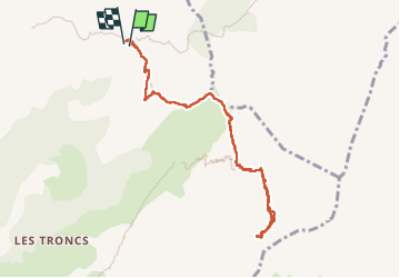
Trail Walking of 9.5 km to be discovered at Auvergne-Rhône-Alpes, Upper Savoy, Le Grand-Bornand. This trail is proposed by jeff2.
Description
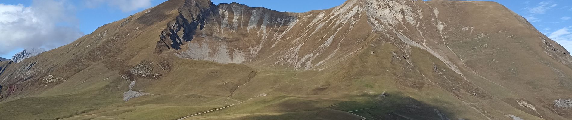
Départ au dessus du grand Bornand dans un petit village appelé "les Annes". Direction la pointe Chombas, pas loin du sommet, j'ai arrêté, la face était à l'ombre et le rocher glissant, super balade, picnic au refuge fermé de la pointe percée. Une bière et je rentre à Cham'.
Positioning
Comments
Trails nearby
![Trail Walking Le Reposoir - Le Petit Bargy 2098 m, depuis Malatrait - Photo](https://media.geolcdn.com/t/375/260/ext.jpg?maxdim=2&url=https%3A%2F%2Fservices.sitytrail.com%2FGeolivesWS%2FDownloadMedia.ashx%3FTrailID%3D215073%26Media%3D15647_1.jpg)
![Walking Walking](https://static1.geolcdn.com/sitytour/trail-icons/101.png)
Walking
![](/images/other/stat-length.png)
![](https://static1.geolcdn.com/siteimages/upload/files/16400158638029165_repeat_loop_refresh_sync_direction_icon.png)
![Trail Touring skiing Le Grand-Bornand - Col de Balafrasse et tout de la pointe Est du midi - Photo](https://media.geolcdn.com/t/375/260/43833717-d102-4f65-80da-59cdd532a1e7.jpg&format=jpg&maxdim=2)
![Touring skiing Touring skiing](https://static1.geolcdn.com/sitytour/trail-icons/503.png)
Touring skiing
![](/images/other/stat-length.png)
![](https://static1.geolcdn.com/siteimages/upload/files/16400158638029165_repeat_loop_refresh_sync_direction_icon.png)
![Trail Touring skiing Le Grand-Bornand - PT 2595au dessus du col des Verts - Photo](https://media.geolcdn.com/t/375/260/adf344e5-4ea3-43cf-966b-fc21b915cec5.jpg&format=jpg&maxdim=2)
![Touring skiing Touring skiing](https://static1.geolcdn.com/sitytour/trail-icons/503.png)
Touring skiing
![](/images/other/stat-length.png)
![](https://static1.geolcdn.com/siteimages/upload/files/16400158638029165_repeat_loop_refresh_sync_direction_icon.png)
![Trail Walking Le Reposoir - au dessus de la grotte de motarquis - Photo](https://media.geolcdn.com/t/375/260/6633e4c3-051b-48bd-b57d-3a22c34b0388.jpg&format=jpg&maxdim=2)
![Walking Walking](https://static1.geolcdn.com/sitytour/trail-icons/101.png)
Walking
![](/images/other/stat-length.png)
![](https://static1.geolcdn.com/siteimages/upload/files/16400158638029165_repeat_loop_refresh_sync_direction_icon.png)
![Trail Walking Le Reposoir - pointe blanche par l'arête Est - Photo](https://media.geolcdn.com/t/375/260/49880efe-479d-4396-9a1d-07cba2b79941.jpg&format=jpg&maxdim=2)
![Walking Walking](https://static1.geolcdn.com/sitytour/trail-icons/101.png)
Walking
![](/images/other/stat-length.png)
![](https://static1.geolcdn.com/siteimages/upload/files/16400158638029165_repeat_loop_refresh_sync_direction_icon.png)
![Trail Walking Le Grand-Bornand - Refuge Gramusset à partir de la Duche - Photo](https://media.geolcdn.com/t/375/260/73111a9a-0fbf-415b-b1f6-9a526784c3a6.jpg&format=jpg&maxdim=2)
![Walking Walking](https://static1.geolcdn.com/sitytour/trail-icons/101.png)
Walking
![](/images/other/stat-length.png)
![](https://static1.geolcdn.com/siteimages/upload/files/16400158638029165_repeat_loop_refresh_sync_direction_icon.png)
![Trail On foot Le Grand-Bornand - Move - Photo](https://media.geolcdn.com/t/375/260/d4eec1a7-be1d-468d-88bd-21b07ef933e8.jpg&format=jpg&maxdim=2)
![On foot On foot](https://static1.geolcdn.com/sitytour/trail-icons/100.png)
On foot
![](/images/other/stat-length.png)
![](https://static1.geolcdn.com/siteimages/upload/files/16400158638029165_repeat_loop_refresh_sync_direction_icon.png)
![Trail Walking Le Reposoir - lac peyre - Photo](https://media.geolcdn.com/t/375/260/ext.jpg?maxdim=2&url=https%3A%2F%2Fservices.sitytrail.com%2FGeolivesWS%2FDownloadMedia.ashx%3FTrailID%3D476460%26Media%3Dfix__20150926104215.jpg)
![Walking Walking](https://static1.geolcdn.com/sitytour/trail-icons/101.png)
Walking
![](/images/other/stat-length.png)
![](https://static1.geolcdn.com/siteimages/upload/files/16400158638029165_repeat_loop_refresh_sync_direction_icon.png)
![Trail Snowshoes Le Grand-Bornand - la duche, Col des Annes, Terres rouges - Photo](https://media.geolcdn.com/t/375/260/ext.jpg?maxdim=2&url=https%3A%2F%2Fservices.sitytrail.com%2FGeolivesWS%2FDownloadMedia.ashx%3FTrailID%3D376536%26Media%3D20150108112903.jpg)
![Snowshoes Snowshoes](https://static1.geolcdn.com/sitytour/trail-icons/504.png)
Snowshoes
![](/images/other/stat-length.png)
![](https://static1.geolcdn.com/siteimages/upload/files/16400158638029165_repeat_loop_refresh_sync_direction_icon.png)